As Applied To Border/Coastal Surveillance and Critical Infrastructure Protection
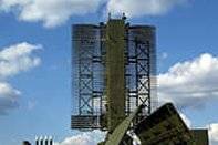
- Sensors (Remote Sensing)
- GPS
- GIS
- Command & Control Application
(Refer to Part I for information on Sensors and GPS)
GIS
The cartographic module is an important component of a C4ISR solution. A detailed digital representation of the area-under-surveillance will allow the user to integrate the data from the sensors and the GPS receivers on to map, and allow the user to associate real-time sensor feed with a location or feature on the map, as well as track its resources visually.
The cartographic module typically imports maps from a third-party and then allows situation-specific interpretation to be imported or added to the maps. Multiple maps can be imported and used, provided they conform to widely used formats.
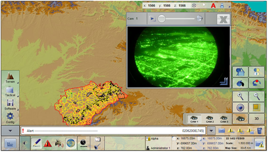 |
| Figure 4: Cartographic representation with sensor feed |
Command & Control Application
The Command & Control component integrates the feed from the sensors and GPS receivers with the cartographic representation of the area-under-surveillance, and allows the user to initiate SOPs in the event of an incident, query and receive additional information from sensors and resources in the field in real-time, and send out instructions to the resources on how to respond to an incident. All of this happens in a co-ordinated manner – even if there are multiple decision-makers participating from different locations – and with all available information at the fingertips of the decision-makers (Common Operational Picture or COP).
The Command & Control Application sometimes also provides, through additional hardware, the capability to patch multiple communications protocols; thereby allowing different field units (some on V/U/HF, others on GSM or CDMA, etc.) to communicate transparently with each other. Such a communications matrix is extremely effective in maintaining command and control during crisis situations.
Finally, given that duplication of information is bound to happen during an incident, the application automatically recognises which reports of an incident are similar, and allows a user to de-duplicate such information.
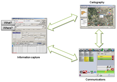 |
| Figure 5: Integration of the various components of a C4ISR solution |
Desiderata of a C4ISR Homeland Security Solution
Choosing a Homeland Security solution – B/CSS or CIP – based on a C4ISR framework should be a decision taken on the basis of support for the following functionality:
- Interoperability: By interacting with legacy systems of involved agencies and with deployed mobile units as well, it is possible to develop a higher resolution picture of a crisis situation. For this purpose, a data model such as the standard JC3IEDM should be used, and web services should be XML-based.
- Sharing Mechanism: Sensor data should be managed by Publication/Subscription mechanisms: the operator subscribes to the information or services offered by the solution, which incorporates a middleware layer in charge of searching for the information and publishing it to subscribers. This allows information to be received and consolidated in a database in real time.
- Openness: Sensor-independence allows the solution to integrate new sensors (based on new technologies) at a future point in time. Cartographic independence allows the solution to support a variety of map formats.
- Architecture: A decentralized and Services-Oriented-Architecture (SOA) allows the system to be managed from any fixed or mobile network device, providing an added robustness, in the event of failures or crisis situations.
- Low-bandwidth protocol: Data synchronization mechanisms used should allow information to be shared in real time, at rates as low as < 10 kbps, for the solution to function effectively in crisis situations.
Case Study
This case study is of a C4ISR B/CSS implementation in Spain, covering Spain’s maritime border with North Africa (specifically Morocco). The problem Spanish authorities had was that this stretch of the maritime border was being used for illegal immigration and drug smuggling, and that the number of incidents were increasing at an alarming rate.
As can be seen from the visual below, the implemented system manages all phases involved in border management. The graph on the right plots the progress of the entity-under-surveillance towards the Spanish shore, with distance from the shore being plotted on the Y-axis, and elapsed time since detection being plotted on the X-axis. The table on the right provides the phase-wise figures for three scenarios – detection at 20 to 16 kilometres, 15 to 11 kilometres, and 10 to 8 kilometres.
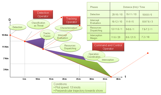 |
| Figure 6: Coastal Surveillance System Spanish Case Study – Typical Operational Performance |
The effect of the C4ISR B/CSS implementation, in this case, has been a staggering fall in the number of incidents featuring illegal crossing and drug-running across the maritime border covered by the solution.
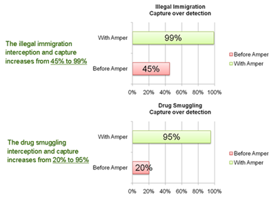 |
| Figure 7: Coastal Surveillance System Spanish Case Study – Operational Impact |
Conclusion
Geo-spatial technologies can be used to deliver a far stronger implementation of Homeland Security solutions. In this connection, it is important to leverage the latest in the respective technologies (remote sensing, GPS, GIS) so that as detailed a COP (Common Operational Picture) as possible, is provided to decision-makers. In addition, these implementations, across various law-enforcement agencies, should support a level of interoperability that will allow them to share relevant information in real-time.
Homeland Security, these days, is too critical a responsibility to be left to addressed through silo-type responses. C4ISR solutions, leveraging the latest in geo-spatial technologies, promise and deliver significant improvements in the manner the state responds to threats to its existence.