As Applied To Border/Coastal Surveillance and Critical Infrastructure Protection
Introduction
With the increasing frequency and diverse nature of threats to the state, what previously used to take place as uncoordinated activities by different branches and chapters of law-enforcement agencies, is now consolidated under an architecture that allows disparate agencies and their chapters to gather specific and useful information, and share the same across a network of interested parties. This architecture, loosely termed Homeland Security is, today, seen as vital to the continued survival of the state.
| Border/Coastal SurveillanceUnregulated borders and coastlines are the chinks in a nation’s homeland security armour. Smuggling (contraband and human trafficking), illegal immigration, and terrorism are the three threats, to a country’s security, most likely to exploit the porosity of unregulated borders and coastlines: think back to the “Mumbai: 26 November” attack, or think of the smuggling of contraband through the borders of Gujarat, Jammu & Kashmir, or Rajasthan. C4ISR Border/Coastal Surveillance Systems (B/CSS) seek to significantly reduce, if not eliminate, the incidence of such activities |
Homeland Security needs to leverage the technological advances and practices of the day, to keep pace with the increasing technological prowess of sources of threats; and the adoption of the C4ISR (Command, Control, Communications, Computing, and Intelligence, Security, Reconnaissance) concept, from military practice, provides Homeland Security the wherewithal to do so.
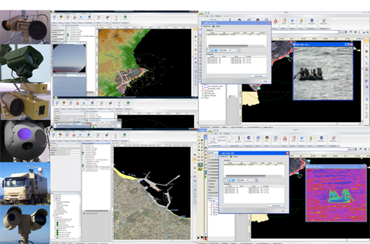
C4ISR can be thought of as a framework for organizing multi-media information emanating from a situation (typically a crisis), in a manner that enables non-local users to analyse such information (from multiple sources); act on that information or advise local players on actions to be taken; receive feedback from local players on actions taken; based on which a follow-up set of actions or advice can be initiated, towards the objective of resolving the situation to the advantage of the users. C4ISR systems make extensive use of technology: especially geo-spatial technologies.
This article provides an overview of the geo-spatial technologies with respect to C4ISR solutions for unregulated Border/Coastal Surveillance and Critical Infrastructure Protection.
Operational Components
Before going into further details of the technologies used in C4ISR solutions, it would be useful to gain a perspective on the operational components of a C4ISR solution, as applied to Border/Coastal Surveillance (B/CSS) and Critical Infrastructure Protection (CIP).
| Critical Infrastructure ProtectionCritical Infrastructure Protection (CIP) is the term used to refer to the systems and processes implemented to ensure that designated critical assets are protected from actions intended to curtail, seriously disrupt, or altogether prevent their functioning. A critical infrastructure need not refer only to physical assets of national importance (ports/airports, nuclear facilities, Parliament, etc.); it may refer to any asset (physical, virtual) considered by an organization (government, parastatal, or private), as vital to its functioning. A C4ISR CIP solution provides comprehensive cover to key infrastructure. |
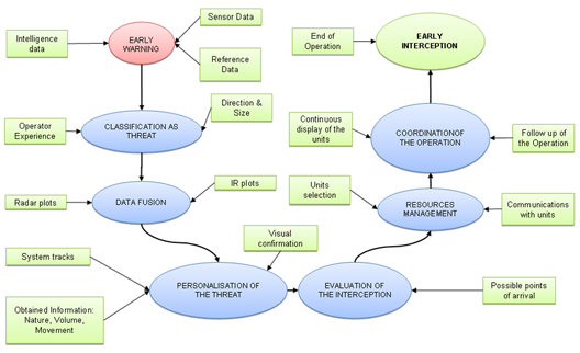 |
| Figure 1: Operational Components of a C4ISR Solution |
As can be seen from the above functional flow, there are four components of a C4ISR solution:
| Sensors (Remote Sensing) | |
| GPS | |
| GIS | |
| Command & Control Application |
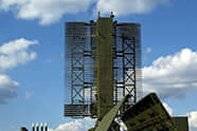
Sensors
Sensors are the eyes, ears, and skin of a surveillance network, and the effectiveness of the surveillance set-up in a particular environment is critically dependent on the type and specifications of the sensors employed in the network. How many times have we heard of a jewelry store heist where the surveillance footage was of little use because the resolution of the installed surveillance cameras was too low; because the lens used was not right; because the entrance-facing camera did not feature a WDR (Wide Dynamic Range) sensor or support BLC (Back-light Compensation).
There are a variety of sensor technologies in the market, and the schematic below lists many of the popular sensors technologies, their delivery platforms, and the communications fabric, with respect to B/CSS and CIP requirements.
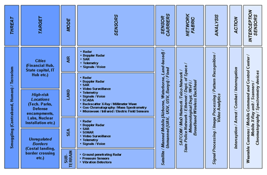 |
| Figure 2: Sensor Technologies and Delivery Platforms |
Given this confusion of options, users typically apply the following thumb-rules when choosing among sensor technologies for specific situations:
| Implement a design comprising of layers of sensors, with each layer delivering an increasing resolution of the entity-under-surveillance, as it approaches a defined boundary: for example, radars may be employed to track entities at a distance of between 5 – 50 kilometres; long-range thermal cameras may be employed to track entities at a distance of between 1 – 5 kilometres; and high-resolution optical cameras may be employed to track entities at a distance of one kilometer and below. | |
| Each layer may be a mix of technologies, such that blind-spots in one technology are visible in another; and, such that counter-measures by the entity-under-surveillance do not render the entire surveillance layer dysfunctional: for example, in the case of surveillance on land, a mix of radars and vibration sensors may be implemented, in one layer, to preclude the possibility of the entity-under-surveillance evading observation by employing radar-masking techniques. | |
| Data from different sensor technologies can be combined to deliver a level of information significantly greater than can be provided by each of the individual technologies in isolation. This data fusion is typically handled at the application level (Command and Control application OR Sensor Management software). |
Choosing a sensor technology will be a function of parameters such as cost (or budget), the potential entities-under-surveillance, surveillance range, the terrain of the area-under-surveillance, and the features to be captured (of the entities-under-surveillance). The following visual shows a range of sensors used in a typical CIP implementation.
 |
| Figure 3: A mix of sensors in a C4ISR solution |
GPS
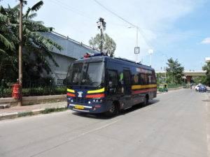
The second important geo-spatial component of a C4ISR solution is the device that allows user resources to be tracked in real-time, in terms of location and movement. All C4ISR solutions include a Blue Force Tracking (BFT) module.
Blue Force Tracking (BFT) is a United States military term used to denote a GPS-enabled system that provides military commanders and forces with location information about friendly (and despite its name, also about hostile) military forces. In military symbology, the colour blue is typically used to designate friendly forces while red is used for enemies, and green or yellow are used for neutral forces.
A BFT system, at its simplest, consists of a GPS device and a means for relaying the GPS information to a monitoring centre: a police patrol unit may have a VHF radio set with the GPS device integrated in the microphone, so that location information is transmitted to the monitoring centre at the touch of a button. More sophisticated BFT systems will allow relaying of mobile sensor data, providing additional information specific to the location, etc.; along with the transmission of the co-ordinates.
Depending on the terrain being traversed, the GPS device will need to support a level of sensitivity that will allow it to function at all times. GPS Receiver Module
Built around the SiRf Star III chip, the GPS Receiver Module from Mistral is the world’s smallest high-sensitivity GPS module. The 20-channel GPS receiver is capable of giving accurate details of Location, Altitude, Velocity, and Direction.
This fully functional RF module receives spread spectrum signals from the MEO (Medium Earth Orbiting) satellites. It features a low-noise RF amplifier with sensitivity below -159dBm; and has the ability to withstand ESD up to 2000V.
The GPS module is PCB mountable, with a very small footprint; and can be easily integrated in a wide range of applications in the defense and consumer electronics segment. These include portable navigation, cellular phones and other communication equipment.